


Mount Kailash and Lake Mansarovar represent two of the most sacred pilgrimage destinations in the world, revered by followers of Hinduism, Buddhism, Jainism, and the Bon religion.
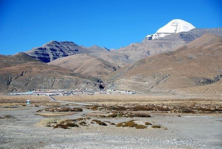
In Hindu tradition, Mount Kailash, located in the Ngari Prefecture of Tibet Autonomous Region in China, stands majestically at 6,638 meters (21,778 ft) in height. In Tibetan, this mountain is known as Kang Rinpoche, which means “Precious Snow Mountain” and is believed to be the abode of Lord Shiva and his consort, Goddess Parvati. For Buddhists, it represents the dwelling place of Buddha Demchok; for Jains, it is where their first Tirthankara, Rishabhanatha, attained liberation; and for followers of the pre-Buddhist Bon religion, it is their spiritual center.
The Kailash Mansarovar Yatra is not merely a journey to visit these sacred places, but a profound spiritual pilgrimage that has drawn devotees for thousands of years. This challenging trek through some of the world’s most remote and breathtaking landscapes offers both physical challenges and spiritual rewards. Beyond the main attractions of Mount Kailash and Lake Mansarovar, the region is home to numerous other sacred sites, natural wonders, and cultural landmarks that enhance the pilgrimage experience.
This comprehensive guide explores the 15 most significant places to visit during the Kailash Mansarovar Yatra in 2025, providing detailed information about each site’s religious significance, geographical features, and practical visitor information. Whether you’re undertaking this journey for religious devotion, cultural exploration, or adventure tourism, understanding these sacred sites will enrich your experience of this once-in-a-lifetime pilgrimage.
Best Time to Visit Kailash Mansarovar in 2025
The Kailash Mansarovar Yatra is highly seasonal due to the extreme weather conditions in the Tibetan plateau. For 2025, the optimal window for pilgrimage will be from mid-May through early October, with specific considerations for each month:
May-June (Highly Recommended):- Weather conditions are most favorable with clear skies
- Daytime temperatures range from 10-15°C (50-59°F)
- Night temperatures typically range between -5 to 5°C (23-41°F)
- Ideal for photography, with Mount Kailash’s snow-capped peak clearly visible
- Weather conditions are most favorable with clear skies
- Daytime temperatures range from 10-15°C (50-59°F)
- Night temperatures typically range between -5 to 5°C (23-41°F)
- Ideal for photography, with Mount Kailash’s snow-capped peak clearly visible
- Increased precipitation may cause road blockages
- Higher humidity and occasional rainfall
- Slightly warmer temperatures between 15-20°C (59-68°F) during daytime
- Lush green landscapes but potentially muddy trekking conditions
- Cloudier views of Mount Kailash
- Post-monsoon clarity returns to the skies
- Moderate daytime temperatures between 5-15°C (41-59°F)
- Increasingly cold nights, often below freezing
- Fewer pilgrims than summer months
- Vibrant autumn colors in the valleys
Sacred Places to Visit in Kailash Mansarovar
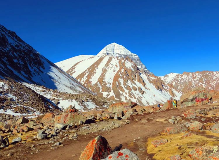
Mount Kailash
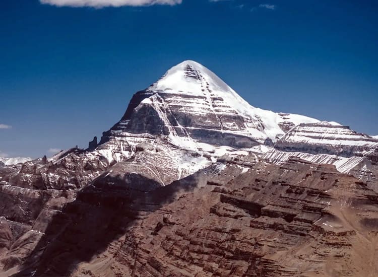
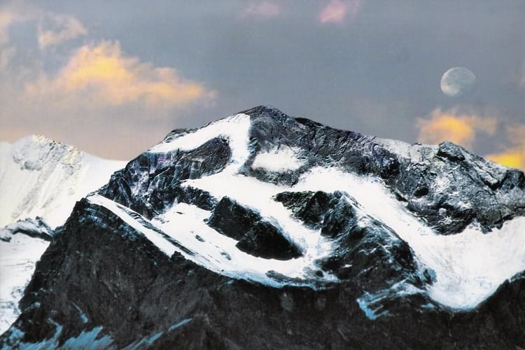
 Mount Kailash (Kailash Parvat) is considered the physical manifestation of the mythical Mount Meru, the spiritual center of the universe in Hindu, Buddhist, and Jain cosmology. For Hindus, it is the abode of Lord Shiva and Goddess Parvati. Buddhists revere it as the dwelling of Buddha Demchok, while Jains believe it is where their first Tirthankara attained liberation. The Bon religion considers it their spiritual headquarters. So, no matter what your religious beliefs are, Mount Kailash is a must-visit in Mansarovar. Geographical Features:
- Elevation: 6,638 meters (21,778 ft) above sea level
- A distinctive four-sided peak resembling a symmetrical pyramid
- Perpetually snow-capped summit
- Four major rivers originate near Mount Kailash: the Indus, Sutlej, Brahmaputra, and Karnali.
- Climbing Mount Kailash is forbidden due to its sacred status
- The mountain is worshipped through circumambulation (parikrama/kora)
- Photography is permitted, but maintain a respectful distance
- The best viewing points are from Darchen, Dirapuk Monastery, and Zutulpuk Monastery
- Country: China
- Region: Ngari Prefecture, Tibet Autonomous Region
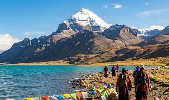
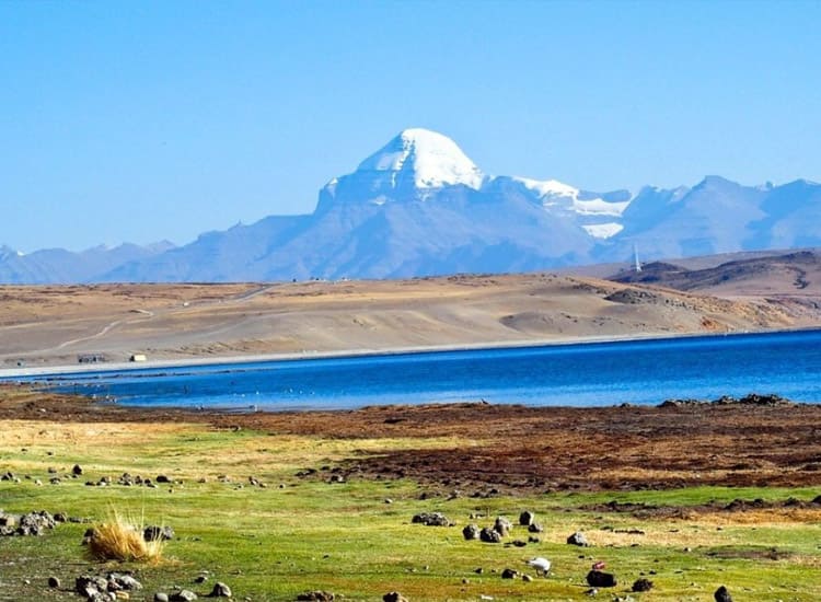
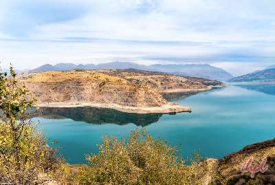
Lake Mansarovar
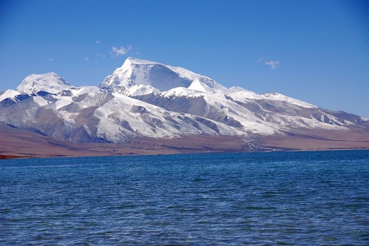 Lake Mansarovar (Manasa Sarovara) is considered one of the holiest lakes in Asia. The name “Mansarovar” comes from Sanskrit, where “Manas” means mind and “Sarovar” means lake, as it was first created in the mind of Lord Brahma. Hindus believe bathing in or drinking from Mansarovar cleanses all sins that have accumulated over a hundred lifetimes. Buddhists associate it with Maya, the mother of Buddha. Geographical Features:
- Elevation: 4,590 meters (15,060 ft) above sea level
- Freshwater lake spanning approximately 88 km (54.7 mi) in circumference
- Maximum depth of 90 meters (300 ft)
- Crystal clear blue waters when calm
- Changes colors from clear blue to emerald green to deep ruby red throughout the day
- Ritual bathing is permitted in designated areas
- Collecting water in bottles is allowed for religious purposes
- Circumambulation of the lake takes approximately 3-4 days on foot
- Vehicle circumambulation is possible in 1 day
- Local boats are available for short trips on the lake (weather permitting)
- Country: China
- Region: Ngari Prefecture, Tibet Autonomous Region
- Elevation: 4,724 meters (15,500 ft) above sea level
- Natural archway formation in the mountain landscape
- Located approximately 15 km from Darchen
- Traditional gateway adorned with prayer flags and stone cairns
- The traditional starting point for the Kailash Parikrama
- Religious ceremonies are often performed here before beginning the circuit
- Pilgrims traditionally leave offerings of coins, prayer flags, or personal items
- Photography is permitted
- Country: China
- Region: Ngari Prefecture, Tibet Autonomous Region
Pashupatinath Temple
 Pashupatinath Temple is one of the most significant Hindu temples dedicated to Lord Shiva in his form as Pashupati, Lord of Animals. It serves as a crucial spiritual connection for pilgrims heading to or returning from Kailash Mansarovar. The temple is considered one of the 275 Paadal Petra Sthalams (holy abodes of Lord Shiva) and is listed as a UNESCO World Heritage Site. Geographical Features:
- Located on the banks of the sacred Bagmati River
- Built in the distinctive Nepali pagoda style with two-tiered gold-plated roofing
- Constructed primarily from timber with metal plating
- Surrounded by numerous smaller temples and shrines
- Non-Hindus cannot enter the main temple but can view it from the eastern bank of the river
- Temple opens at 4:00 AM for morning rituals and closes at 9:00 PM
- Cremation ghats along the river are active throughout the day
- Photography from designated areas only
- Modest dress code strictly enforced
- Country: Nepal
- Region: Kathmandu
Gauri Kund
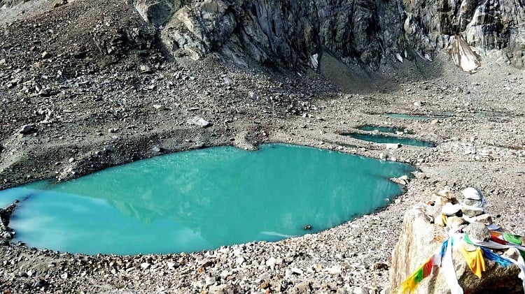 Religious Significance: Gauri Kund, also known as Parvati Sarovar, is a sacred lake dedicated to Goddess Parvati. According to Hindu mythology, it is the place where Goddess Parvati created Lord Ganesha from the soap lather on her body and breathed life into him. The emerald green waters are believed to have special purifying properties for women seeking fertility blessings. Geographical Features:
- Elevation: Approximately a5,608 meters (18,400 ft) above sea level
- Small emerald-green lake fed by glacial melt
- Located on the Kailash Parikrama route between Yam Dwar and Dirapuk
- SOften partially frozen, even during summer months
- Located approximately 5 km from Darchen on the Kailash Parikrama route
- Women pilgrims often perform special prayers here
- Collecting water is permitted for religious purposes
- Best visited during midday when sunlight illuminates the green waters
- No facilities available nearby
- Country: China
- Region: Ngari Prefecture, Tibet Autonomous Region
Tirthapuri
 Tirthapuri is an important Buddhist pilgrimage site associated with Guru Padmasambhava (also known as Guru Rinpoche), who is credited with introducing Buddhism to Tibet. The site features the Tirthapuri Monastery and sacred hot springs where pilgrims bathe to cleanse themselves of sins after completing the Kailash Parikrama. Geographical Features:
- Located on the north bank of the Sutlej River
- Natural hot springs with mineral-rich waters
- Dramatic limestone formations and caves used for meditation
- Monastery complex built into the hillside
- Located approximately 85 km west of Mount Kailash
- 1-hour circumambulation path around the main sacred sites
- Hot spring bathing is available in segregated pools
- The monastery contains precious artifacts and scriptures
- Simple guest houses are available for overnight stay
- Country: China
- Region: Ngari Prefecture, Tibet Autonomous Region
Om Parvat
 Om Parvat is renowned for its distinctive rock formation, which resembles the sacred Hindu symbol ‘Om’ (ॐ) when viewed from a distance. According to the Shiva Puran, the concept of ‘Om’ originated even before the universe was formed. Its natural representation appeals to both pilgrims and photographers with its awe-inspiring sight. Geographical Features:
- Elevation: 5,590 meters (18,340 ft) above sea level
- Located near the Nepal-India-China tri-junction
- Snow patterns naturally form the Sanskrit “ॐ” symbol on the north face
- Visible from the Indian side near Lipulekh Pass
- Best viewed from Nabhidhang camp on the way to Lipulekh Pass
- Binoculars are recommended for clear viewing
- Most visible during clear weather in May-June and September-October
- Photography is permitted and encouraged
- Special permits are required as it falls in a border area
- Country: Uttarakhanda
- Region: Pithoragarh, Uttarakhand
Rakshas Tal
 Rakshas Tal (Demon Lake) stands in stark contrast to the holy Mansarovar Lake nearby. According to Hindu legend, the fierce demon king Ravana performed severe penance here to please Lord Shiva. The lake represents darkness and is rarely used for religious rituals, though Buddhists believe that eventually, this lake too will become holy. Geographical Features:
- Elevation: 4,575 meters (15,010 ft) above sea level
- Saltwater lake connected to Lake Mansarovar by a narrow channel called Ganga Chhu
- Crescent-shaped with deep blue waters
- Approximately 75 km in circumference
- Unlike Mansarovar, it contains no aquatic life
- Located just 5 km west of Lake Mansarovar
- No ritual bathing is performed here
- Stunning photographic opportunities, especially at sunrise/sunset
- Full circumambulation is not commonly practiced
- Local belief discourages spending the night nearby
- Country: China
- Region: Ngari Prefecture, Tibet Autonomous Region
Muktinath Temple
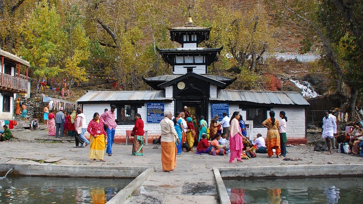 Muktinath Temple is sacred to both Hindus and Buddhists. For Hindus, it is one of the 108 Divya Desams (sacred Vishnu temples) and the only one located outside India. The name “Muktinath” means “place of liberation,” and it is believed that visiting this temple breaks the cycle of rebirth. Buddhists know it as Chumig Gyatsa (Hundred Waters) and associate it with Avalokiteshvara. Geographical Features:
- Elevation: 3,800 meters (12,470 ft) above sea level
- The Temple complex features 108 water spouts shaped as bull heads
- Natural eternal flame (from natural gas) burns alongside water
- Located in the Annapurna mountain range
- Ancient pagoda-style temple architecture
- Accessible via road from Jomsom or by trekking the Annapurna Circuit
- Helicopter services are available from Pokhara and Kathmandu
- Open year-round, best visited April-June or September-November
- Accommodation is available in the nearby Ranipauwa village
- Hindu priests and Buddhist monks both maintain the temple
- Country: Nepal
- Region: Mustang District
- Coordinates: 28°49′N 83°52′E
Saptarishi Caves
 The Saptarishi (Seven Sages) Caves are believed to be where the seven great sages of Hindu tradition meditated in the presence of Lord Shiva. Among these sages were Kashyapa, Atri, Vashishtha, Vishwamitra, Jamadagni, Bharadwaja, and Gautama, who received divine knowledge directly from the gods. Geographical Features:
- Elevation: Approximately 6,000 meters (19,685 ft) above sea level
- Natural cave formations in the rocky landscape
- Located on the outer Kailash Parikrama route
- 13 preserved chortens (Buddhist monuments) nearby
- Difficult access requiring experienced guides
- Special permission is required to visit
- Accessible only during peak season (June-September)
- Not on the main Kailash circuit; requires additional trekking
- No facilities available; day trip only
- Local guides are essential due to the challenging terrain
- Country: China
- Region: Ngari Prefecture, Tibet Autonomous Region
- Coordinates: Not precisely mapped; approximately 10 km northwest of Mount Kailash
Nandi Parvat
 Nandi Parvat is named after Nandi, the sacred bull who serves as Lord Shiva’s mount and gatekeeper of Mount Kailash. In Hindu tradition, Nandi represents strength, fertility, and devotion. The mountain is believed to embody Nandi’s eternal vigilance guarding the abode of Lord Shiva. Geographical Features:
- Elevation: Approximately 6,000 meters (19,685 ft) above sea level
- Bull-shaped mountain formation visible from certain angles
- Located in the vicinity of Mount Kailash
- Part of the greater Himalayan range
- Often snow-covered year-round
- Visible during the Kailash Parikrama route
- No separate trek required; viewed as part of the Mount Kailash circuit
- Best photographed from the northern section of the Kailash circuit
- Local guides can point out the specific formation
- Country: China
- Region: Ngari Prefecture, Tibet Autonomous Region
- Coordinates: Approximately 8 km northeast of Mount Kailash
Guge Kingdom
 Though not primarily a religious site, the Guge Kingdom ruins represent an important chapter in the history of Buddhism in Tibet. Founded in the 10th century by a descendant of the Tibetan royal family, Guge became an essential center for translating Buddhist texts and spreading Buddhism throughout western Tibet before its mysterious disappearance in the 17th century. Geographical Features:
- An ancient fortress city built into steep hillsides
- The complex of temples, palaces, and caves spans multiple levels
- Clay and stone construction is typical of ancient Tibetan architecture
- Well-preserved murals and sculptures inside the remaining structures
- Located approximately 1,200 km from Lhasa
- Requires special permits in addition to standard Tibet permits
- Guided tours available through the ruins
- Limited accommodation in nearby Zanda County
- Photography is permitted in most areas (no flash in rooms with murals)
- Country: China
- Region: Tholing, Zanda County, Tibet Autonomous Region
Jal Narayan Vishnu Temple
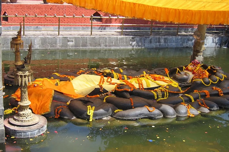 Also known as Budhanilkantha Temple, the Jal Narayan Vishnu Temple houses an impressive 5-meter-long statue of Lord Vishnu reclining on a bed of serpents in a pool of water. This represents Vishnu in his cosmic sleep (Yoga Nidra) during the intervals between creation cycles of the universe. The temple is especially significant for devotees undertaking the Kailash Yatra as Vishnu is believed to bless pilgrims with safe passage. Geographical Features:
- Temple constructed around a large water tank
- Ancient stone carving of Vishnu from a single block of black basalt
- Located at the base of Shivapuri Hill
- Surrounded by a walled compound with smaller shrines
- A natural spring feeds the water pool surrounding the statue
- Located 9 km from central Kathmandu
- Open daily from 4:00 AM to 10:00 PM
- Non-Hindus can view from the perimeter, but cannot approach the statue
- Religious ceremonies performed daily at dawn and dusk
- Country: Nepal
- Region: Kathmandu
- Coordinates: 27°46′N 85°22′E
Ashtapad
 Ashtapad is of supreme importance to Jains as it is believed to be where Rishabhanatha, the first Tirthankara (enlightened teacher) of Jainism, attained nirvana. The name “Ashtapad” means “eight steps,” referring to the mountain’s distinctive eight-stepped formation. For Hindus, it is associated with the mythical king Bharata, who is said to have built a palace here. Geographical Features:
- Elevation: Often identified with peaks near Mount Kailash
- Eight-peaked mountain formation
- Remote location in the Himalayan range
- Rugged terrain with limited access routes
- Exact location disputed among scholars
- Located in the vicinity of Darchen
- Limited access due to geographical challenges
- Special permission required
- Local guides familiar with Jain traditions recommended
- No facilities available; day trip only
- Country: China
- Region: Purang County, Tibet Autonomous Region
- Coordinates: Near Darchen, exact location contested
Damodar Kund
 Damodar Kund is named after Lord Krishna’s childhood name, “Damodar” and is considered sacred in Hindu tradition. The twin lakes at this site (Damodar Kund and Gauri Kund) are believed to remove sins and purify the soul of anyone who bathes in them. This site is especially important for those who wish to perform rituals for deceased ancestors. Geographical Features:
- Elevation: 4,980 meters (16,339 ft) above sea level
- Twin high-altitude alpine lakes
- Surrounded by the Annapurna and Damodar Himalayan ranges
- Source of the Kaligandaki River
- Pristine, emerald-colored waters
- Located in the Upper Mustang region, requiring special permits
- Accessible via helicopter or multi-day trek from Jomsom
- Best visited during May-June and September-October
- No permanent facilities; camping equipment necessary
- Local guide mandatory due to remote location
- Country: Nepal
- Region: Upper Mustang
- Coordinates: Approximately 29°11′N 83°58′E
Kailash Parikrama: The Sacred Circumambulation
The Kailash Parikrama (called Kora by Tibetans) is the ritual circumambulation of Mount Kailash and represents the spiritual heart of the pilgrimage. This 52-kilometer circuit around the sacred mountain is typically completed over three days, though some devout pilgrims perform it in a single day (which is physically demanding at high altitude) or by performing full-body prostrations, which can take up to four weeks. The Three-Day Standard Route: Day 1: Darchen to Dirapuk (20 km)- Starting Point: Yam Dwar near Darchen (4,724 m)
- Major Sites: Tarboche flagpole, Chuku Monastery, western face of Kailash
- Destination: Dirapuk Monastery (5,050 m)
- Terrain: Gradual ascent through river valleys
- Duration: 6-8 hours of walking
- Views: North face of Mount Kailash with spectacular sunset colors
- Starting Point: Dirapuk Monastery (5,050 m)
- Major Challenge: Dolma La Pass (5,630 m), the highest point of the circuit
- Sacred Sites: Gauri Kund, Shiva-sthal
- Destination: Zutulpuk Monastery (4,790 m)
- Duration: 7-9 hours of walking
- Special Features: Prayer flag-covered pass, meditation caves
- Starting Point: Zutulpuk Monastery (4,790 m)
- Terrain: Gentle path through grasslands and streams
- Destination: Darchen (4,724 m)
- Duration: 3-5 hours of walking
- Completion Ritual: Many pilgrims visit Lake Mansarovar for a holy dip after completing the circuit
- For Hindus: One Kailash Parikrama erases the sins of a lifetime; 108 circuits achieve liberation (moksha)
- For Buddhists: The circuit represents the Wheel of Life and leads to good fortune
- For Jains: It honors the site where the first Tirthankara attained liberation
- For Bon practitioners: The circumambulation is performed counterclockwise (opposite to other faiths)
Essential Travel Information for Kailash Mansarovar Yatra
Permit Requirements for 2025 For 2025, the permit system for Kailash Mansarovar Yatra remains complex and requires advance planning. All visitors must obtain multiple permits: Tibet Travel Permit (TTP):- Primary permit required for all foreign visitors to Tibet
- Must be arranged through authorized Chinese travel agencies
- Processing time: 15-20 days
- Requirements: Valid passport, visa application form, passport photos
- Secondary permit required for travel to “unopened” areas of Tibet including Mount Kailash
- Arranged by your travel agency in Tibet
- Processing time: 3-5 days after arrival in Tibet
- Requirements: Tibet Travel Permit, itinerary details
- Required for sensitive border areas including Mount Kailash and Lake Mansarovar
- Arranged by your travel agency
- Processing time: 7-10 days
- Requirements: Detailed itinerary, group information
- Cost: Included in package tours
- Required for entry into Nepal
- Available on arrival at Kathmandu airport or land borders
- Duration options: 15, 30, or 90 days
- Requirements: Valid passport, passport photos, visa fee
Health and Safety Considerations
Altitude Sickness Prevention:- Gradual Acclimatization: Spend 2-3 days in Kathmandu (1,400m) and Nyalam (3,750m) before proceeding higher
- Hydration: Drink 4-5 liters of water daily
- Medication: Consider Diamox (Acetazolamide) after consulting with your physician
- Pace: Ascend slowly; “climb high, sleep low” principle
- Diet: Easy-to-digest foods, avoid alcohol and caffeine
- Rest: Adequate sleep and rest days in the itinerary
Routes to Kailash Mansarovar
Multiple routes lead to Kailash Mansarovar, each offering different experiences, challenges, and scenic highlights: 1. Nepal-China Highway Route (Most Common):- Starting Point: Kathmandu, Nepal
- Border Crossing: Kodari/Zhangmu or Rasuwagadhi/Gyirong
- Major Stops: Nyalam, Saga, Paryang, Darchen
- Duration: 7-8 days to reach Mount Kailash
- Terrain: Paved roads with high mountain passes
- Highlights: Diverse landscapes from lush Nepal to arid Tibetan plateau
- Difficulty: Moderate, good for most fitness levels
- Starting Point: Delhi → Kathgodam → Dharchula, India
- Border Crossing: Lipulekh Pass
- Major Stops: Tawaghat, Budhi, Gunji, Kalapani, Taklakot
- Duration: 10-12 days to reach Mount Kailash
- Terrain: Mixed trekking and vehicle transport
- Highlights: View of Om Parvat, a traditional Hindu pilgrimage route
- Difficulty: Challenging, requires good physical condition
- Starting Point: Delhi → Gangtok, Sikkim
- Border Crossing: Nathu La Pass
- Major Stops: Hangu Lake, Shigatse, Saga, Darchen
- Duration: 9-10 days to reach Mount Kailash
- Terrain: Mostly motorable roads
- Highlights: Easier altitude adjustment, comfortable journey
- Difficulty: Easiest route, suitable for older pilgrims
- Starting Point: Kathmandu → Nepalgunj → Simikot
- Border Crossing: Hilsa
- Major Stops: Simikot, Hilsa, Taklakot, Darchen
- Duration: 7-8 days to reach Mount Kailash
- Terrain: Initial trek followed by vehicle transport
- Highlights: Remote mountain villages, authentic culture
- Difficulty: Moderate to challenging
- Starting Point: Kathmandu or Nepalgunj
- Helicopter to Hilsa border, then vehicle transport
- Duration: 4-5 days to reach Mount Kailash
- Advantages: Significantly reduces trekking time
- Considerations: Weather dependent, higher cost
- Difficulty: Easiest but most expensive option
- Most Reliable: Nepal-China Highway Route
- Most Scenic: Simikot-Hilsa Route
- Most Comfortable: Nathu La Route
- Most Traditional: Lipulekh Pass Route
- Fastest: Helicopter to Hilsa Option
Conclusion
The Kailash Mansarovar Yatra represents one of the most profound spiritual journeys available to pilgrims, trekkers, and cultural explorers. In 2025, this sacred pilgrimage continues to offer transformative experiences while challenging visitors physically and spiritually. These 15 sacred places to visit in Kailash Mansarovar are among the most important sites in the region, each offering its own religious significance, geographical wonder, and visitor experience. This guide offers practical information, including the best times to visit, permit requirements, health considerations, route options, and accommodation details, to help you prepare thoroughly for this challenging expedition. While the logistical complexities can be significant, countless pilgrims have successfully completed this journey for thousands of years, often without the modern conveniences that we have today. For 2025, consider booking your Kailash Mansarovar Yatra well in advance to secure permits and accommodations during optimal weather windows. Work with reputable tour operators who specialize in this region and can provide the necessary support for a safe and meaningful journey. Kailash Mansarovar Yatra Packages [sc name=”kailash-mansarovar-yatra-packages”][/sc][Check out some Kailash Mansarovar Yatra Packages]
Related Post: कैलाश मानसरोवर यात्रा 2025 की तैयारी कैसे करें Kailash Mansarovar Yatra : Holy Journey of a Lifetime 5 Kailash Yatras to Attain Salvation Travel Tips To Keep In Mind For Kailash Mansarovar Yatra